
Topographic Survey Planning Before Building Near a Rock Ledge
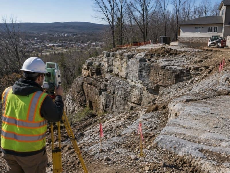
Building near a rock ledge changes how a site comes together. The ground rarely sits flat, the soil can run thin, and hard rock often waits close to the surface, where ridges and rocky outcrops shape a lot of lots, this shows up often. So before anyone settles on a foundation spot, it helps to know what the land really looks like. That’s why many owners start by searching for land survey companies near me and asking for a topographic survey. A good survey maps the shape of the land and hands designers real numbers instead of guesses.
How a Topographic Survey Defines the Rock Ledge Area
A topographic survey records the ground the way it actually sits. The surveyor marks the visible edge of the ledge, then measures how the elevation rises and falls across the site. The surveyor captures slope breaks too, so the sharp spots and the gentle ones both land on the map.
Once those points come together, you get a clear picture of the terrain around the ledge. The map shows the surrounding ground, the drop-offs and the flatter areas where a building might sit. Every reading ties back to a known height, so the whole map speaks the same language. With that view in hand, a designer can study the site before choosing a final location instead of reacting to surprises later on.
Planning a Building Footprint Around Shallow Rock Conditions
Shallow rock has a big say in where a structure fits. When solid rock sits just below the surface, some parts of the lot turn harder to build on than others. So the planned footprint needs to line up with what the survey shows about the ground.
Designers compare the building outline against the elevation changes across the site. Areas with steady, workable ground usually make better spots for the main structure. Places where the rock climbs close to the surface may call for extra effort, and shifting the footprint a few feet can save real trouble. Because the survey gives measured numbers, these choices rest on facts rather than hunches.
Identifying Grade Changes Between the Building Site and Rock Ledge
Grade can shift fast near a ledge. One part of the yard might sit level while another drops off within a short distance. When that happens, careful measurement matters, since even a small stretch of ground can hold a steep change.
Detailed elevation data shows exactly how quickly the land falls between the building site and the edge. That gap, the space between the planned structure and the ledge, becomes the transition area. Designers study it to see how much usable room they really have. A clear read on that distance helps them place the building at a safe, sensible spot rather than crowding the drop.
Using Topographic Survey Information to Coordinate Excavation Planning
Early excavation planning goes smoother once the survey has mapped the ground. If shallow rock might turn up, the survey points reveal where the ground sits high and where digging could get tricky. Crews can flag those trickier spots before any equipment rolls in.
This is also where topographic data connects to later field work. The same measured ground feeds into a construction survey, which sets out the building lines and grades once the design is final. So the topographic map isn’t only a snapshot. It becomes a starting point that guides how the site gets prepared, and spotting the harder zones early keeps the excavation plan realistic.
Reviewing Access and Drainage Paths Near a Rocky Building Site
The land around a ledge shapes more than the building spot. It also decides how people and equipment reach the site and where water runs after a storm. Water almost always finds the lowest path, and rock can steer it in ways that aren’t obvious from ground level. A rocky slope can block an easy driveway route or push runoff toward one corner of the property.
Before construction planning moves ahead, it pays to review these paths against the proposed building location. The survey shows the natural low points and the routes water tends to follow across the ground. When a team checks access and drainage alongside the building spot, the whole plan holds together better. Skipping that step near a rock ledge tends to create headaches once work begins.
Frequently Asked Questions
What is a topographic survey used for before building near a rock ledge?
It captures the elevations and the major terrain shifts around a proposed building area. That record gives planners a solid read on the existing conditions before they commit to a spot.
Can a topographic survey show where shallow rock is located?
A topographic survey mainly captures what sits on the surface. Confirming how deep the rock runs, and how far it spreads, usually calls for added testing below the ground.
Why are elevation changes important near a rock ledge?
Accurate elevation readings reveal how fast the ground rises or drops near the edge. That detail helps everyone see how much workable space the site offers for the planned structure.
Should a topographic survey be completed before finalizing the building location?
Yes, because it supplies existing-condition data that lets designers weigh the location against slopes, ledges and the surrounding terrain. Choosing a spot with that information tends to prevent costly changes later.
How can shallow rock affect construction planning?
Shallow rock can shape excavation, foundation choices, grading and other site-prep decisions. Knowing about it early lets a team plan around it instead of hitting it by surprise.
