The “Call Before You Dig” mantra is used by the ONE CALL SYSTEM community (or 811) where all of the underground utility companies have banded together to try to keep their utility mains from being damaged. This not only costs them money, but most times it also costs the person who is digging.
I want to start a mantra for the Land Surveying Community – “CALL BEFORE YOU BUILD.”
Call A Land Surveyor Before You Build
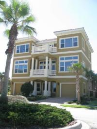
This 5,300-square-foot house along Ocean Ridge Boulevard North in the Ocean Hammock area of Flagler County was built on the wrong lot.
This story about a property line nightmare was published this past Friday. Imagine that you have built your dream home (maybe not $700k worth) and you find you have built on the wrong lot. As Keystone Homes Vice President Richmond told the News-Journal. “It does happen, but it’s rare.”
Now the neighbor NOR the home buyer want to agree to a solution to help the builder (and surveyor) out. They want to weigh all of their options. Do you think one option is to sue everybody within a shotgun radius? This would be the typical course of action.
While this may be rare, the story does mention that this has happened eighteen (18) times within the last twenty (20) years or so. That’s too many.
More Frequent Property Line Story
What is WAY MORE frequent is that a portion of a home is built over a property line or a side setback line. I’ve seen dozens of examples of this. In EVERY instance, this is an expensive proposition for the land owner. There are relatively simple solutions to these after the fact, but the simple solution is usually not agreed to by your neighbor. Usually the offended neighbor sees dollar signs when this is discovered. First anger, then dollar signs. And rightly so. The decision not to have the property lines marked before adding ANY structure on your lot is ill-advised at best.
Cutting Building Costs in the Wrong Place
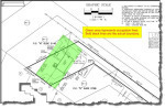
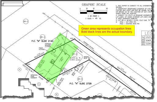
Survey of Property Line Problem
Of course, I DO lay some blame on the builders as well, be it a fencing company, a landscaping company, or a builder. These contractors should know that establishing the limits of construction is one of the very FIRST tasks that should be done. So, why don’t they do it? Money. We strive to save money, but sometimes a little money spent up front will save a LOT of money in the end. Again, I’ve seen this happen on lots of occassions on a land survey.
Now, to be fair, this builder DID call a land surveyor and the surveyor got it wrong. This does happen, but it is rare also. So, there is a lesson for us surveyors also. Mistakes happen, but you are also responsible for your actions, especially for your crews actions.
If you’re starting ANY type of building project on your property it is HIGHLY advisable to have a surveyor mark your property lines and any easements or setback lines that are near the planned construction site. Call a surveyor at Chattanooga Land Surveying today at (423) 702-6505 or fill out a contact request.